|
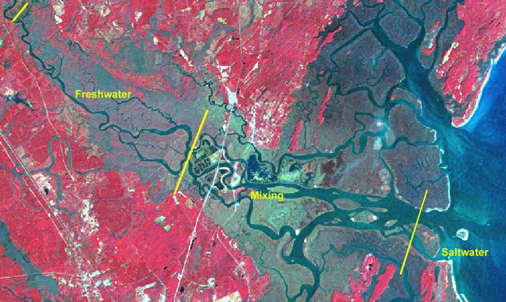
An estuary is a place where freshwater from a river mixes with saltwater from the ocean. The estuary of the Altamaha River is in Glynn and McIntosh Counties in southeastern Georgia. The freshwater in the river has flowed from upland Georgia. The saltwater comes from the Atlantic Ocean. This estuary occupies an area of about 45.25 square kilometers (km2) or 17.47 square miles (miles2). This is about the size of (something familiar which is about 4 mi x 4 mi). Saltwater, the water in oceans, is water that contains salt and minerals. In fact, saltwater has about 35 gallons of salt for every 1,000 gallons of water. Freshwater, the water in rivers and lakes, contains few minerals. This is the water we drink. In an estuary, the amount of salt in the water varies. Special animals and plants live in this environment. They are adapted to live in a wetland with varying salinity. Water in the rivers and oceans comes from rain. Rain is part of the water cycle. Look at the picture of the Altamaha River estuary. Three quarters (3/4) of the estuary area is a water mixing zone (center of the picture). Here, freshwater mixes with saltwater. In the remaining parts of the estuary there is not much mixing of freshwater and saltwater. There is a saltwater area (left side of picture) at the mouth of the river (downstream end). The upstream end of the estuary (right side of picture) is a tidal freshwater area. Here, the freshwater is beyond the reach of saltwater from the ocean. In this portion of the river, water levels are affected by the ocean tides. The water level rises and falls twice a day in rhythm with the tides. The flow of freshwater in the river slows as seawater is pushed into the mouth of the river. |
 |
|||
| Click here to see a larger picture | ||||