| page last updated |
| River Tour | Estuary | Salt Marsh | ||
| What is an Estuary? > Climate > Geology > Surface Water > Ground Water > Aquatic Habitat > Upland Habitat > Ecological Processes > Animals and Plants > Socioeconomic Values > Human Impacts and Pollution > Where does Your water come from? > Management Issues > Protecting YOUR Watershed | ||
|
K-12
Students Site
|
||
| What is an Estuary > Altamaha River Watershed > Water Cycle > Hydrology > Tides > Animals and Plants | ||||||
 |
||||||
|
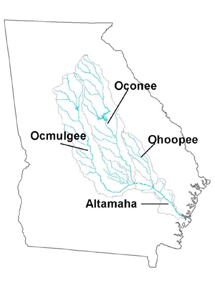
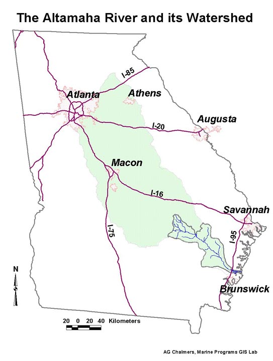
The Altamaha River and its Watershed The Ocmulgee River and the Oconee River come together and form the Altamaha River in southeast Georgia. The Altamaha River flows into the Atlantic Ocean near Darien, at about the mid-point of Georgia's coastline. A watershed is an area of land drained by a river system. When rain falls, some soaks into the soil. The rest of the rainwater remains above ground and begins to flow downhill (for more information, see Hydrology - Surface Water). In a watershed, rain runs downhill until it reaches a stream. Small streams join other streams. The streams continue to flow downhill into a river. Eventually the river flows into the sea. Each large river has many smaller rivers and streams flowing into it. These streams and rivers that flow into a larger river are called tributaries of the river. The watershed of the Altamaha and its tributaries drains the rainfall of nearly one quarter (1/4) of the state. This area includes the cities of Athens, Macon, and Milledgeville and parts of Atlanta. The river and its tributaries carry millions of gallons of fresh water to the estuary and coastal area every day. Nutrients and sediments (soil particles eroded by the water flow) also get carried along. This means that rain that falls in Atlanta will eventually flow down the Altamaha River and out into the Atlantic Ocean! Unfortunately, this also means that any pollution in the water will also flow down the river and end up at the coast. The river and its swamps and marshes near the coast are among the most unspoiled habitats in the state. However, increasing population in the Coastal Plain and pressure for development are threatening their undisturbed nature. |
||||||
| Click on the image to see a larger map. | ||||||
 |
||||||