| page last updated |
| River Tour | Estuary | Salt Marsh | ||
| What is an Estuary? > Climate > Geology > Surface Water > Ground Water > Aquatic Habitat > Upland Habitat > Ecological Processes > Animals and Plants > Socioeconomic Values > Human Impacts and Pollution > Where does Your water come from? > Management Issues > Protecting YOUR Watershed | ||
|
K-12
Students Site
|
||
| Geology > Physiographic Provinces > Aquifers > Ground Water > Surface Water | |||||
|
Geology is the study of the structure of the earth and the processes that have formed it over time. Rivers are affected by the geology and topography (land surface features such as hills, valleys, rivers, and lakes) of the areas they flow through. Some types of soil and rocks absorb more rainwater than other types. When the soil does not absorb much water, most of the water runs downhill to streams. As the slope
of the land becomes steeper, water flows more quickly. It becomes less
likely to soak into the ground and more likely to flow into streams. Thus,
geology and topography determine these aspects of a river: how much water
soaks into the ground; how much runs into river and stream channels; how
fast the water flows; and how quickly the rocks and soil erode. As water
runs down a river, soil and rocks on the sides and bottom of the river
are worn off. These eroded soil and rock bits, called sediment, are carried
downstream. Eventually the sediment settles at the bottom of a calm stretch
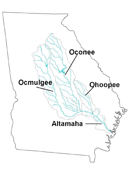
of the river, or it may be swept along until it reaches the ocean. The rivers
of the Altamaha River
watershed are affected by the geological regions they cross.
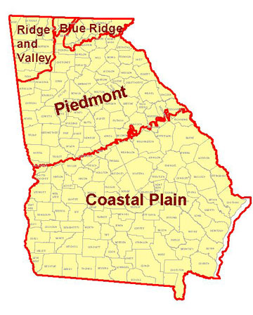
The Piedmont region is an area of rolling plains and gentle hills. The
soil is rich and includes clay and sand. Underneath the soil lies a base
of hard crystalline rocks. The topography of the Coastal Plain region
is mostly flat. The soil is sandy and porous (full of tiny air holes).
Limestone, a type of rock with holes through it, lies underneath the soil.
In the northern
part of the Altamaha River watershed (Piedmont region), most rainwater
runs into streams and rivers. The rich soil and hard rock below do not
allow much water to soak in. Water runs quickly downhill in this hilly
landscape. In the flatter southern part of the watershed (Coastal Plain
region), less rainwater flows into stream channels. Most of the rainwater
drains into the porous sandy soil and limestone. To learn more about river flow and the processes that shape the Altamaha River, read about its Hydrology. |
 |
||||
| click on the images for a larger view | |||||
 |
|||||