| Georgia's River Basins > The Water Cycle > Hydrology > Map of Basins | |||
| What is a River Basin? | ||||||||
| A river basin is all of the area on the face of the earth from which the river collects the water that runs in it. Rain falling within a river basin (or watershed) will run downhill until it reaches a stream. Small streams join other streams and eventually flow into a river and eventually that river flows into the sea. Each large river is made up of many smaller rivers and streams. | 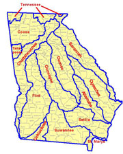 |
|||||||
| Georgia's River Basins | ||||||||
|
Six river basins lie completely within Georgia's borders. The Oconee and the Ocmulgee Rivers join to form the Altamaha River, which empties into the Atlantic Ocean. The Ogeechee and Satilla Rivers also flow to the Atlantic. The Flint joins the Chattahoochee near the Florida border to form the Appalachicola River, which empties into the Gulf of Mexico. Portions of 8 other river basins lie within the state. The Chattahoochee, Savannah and St. Marys Rivers each form portions of Georgia's border. The lower Chattahoochee is part of the border between Georgia and Alabama; the Savannah is the border between Georgia and South Carolina; and the St. Marys forms part of Georgia's border with Florida. |
||||||||
| Click on the map to see a larger version. | ||||||||
To see a list of Georgia's river basins and the counties that lie within them:
                 sorted by county name
                 sorted by basin name
|
||||||||