| page last updated |
| Georgia's River Basins | Georgia's Geology | Georgia's Climate | Altamaha River Basin | ||
| Altamaha Basin > Hydrology > Water Quality > Environmental Threats > Human Impacts > Cultural Features > Coastal Habitats > Tributaries > Plants > Animals > Sapelo Island | ||
|
General
Interest Site |
| Rice Culture | |||||||||
 |
 |
||||||||
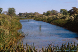
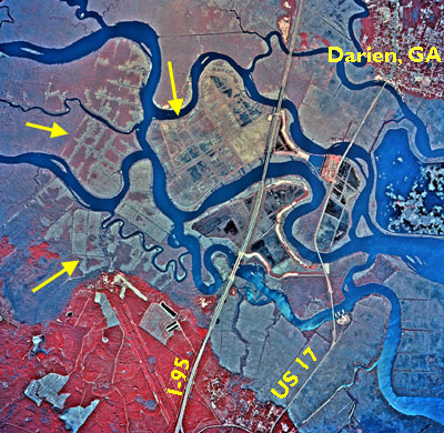
| During the 1800's, plantation owners along the Altamaha and other coastal rivers grew rice in marshes along the river. In those days, sea level was a bit lower than it is today and the river was less salty near Darien than it now is. The picture above is of a straight canal, dug by men (probably by slaves before the Civil War) that was used to bring water to the rice fields. The picture to the right is an aerial photo taken with color infra-red film (grass and trees show up as red with this film). The arrows point to areas where old rice canals and fields can still be seen. From the ground they would look like the picture above. | |||||||||
| Fields would be flooded with river water 3 times: first, to sprout the newly planted seeds, the fields were flooded for 8 to 10 days during high tides in March; second, about 3 weeks later the fields were flooded a second time for 10 to 30 days; third, the fields were flooded in late June and kept flooded until harvest time in August. | |||||||||
| <— Upstream | Downstream —> | ||||||||
| Downstream 2 —> | |||||||||