| Georgia's Geology> Physiographic Provincess> Map of Provinces > Georgia's Aquifers | |||
|
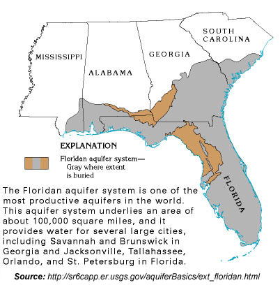
The Floridan aquifer system is one of the most productive aquifers in the world. This aquifer system underlies an area of about 100,000 square miles in southern Alabama, southeastern Georgia, southern South Carolina, and all of Florida. The Floridan aquifer system provides water for several large cities, including Savannah and Brunswick in Georgia; and Jacksonville, Tallahassee, Orlando, and St. Petersburg in Florida. In addition, the aquifer system provides water for hundreds of thousands of people in smaller communities and rural areas. Locally, the Floridan is intensively pumped for industrial and irrigation supplies. During 1985, an average of about 3 billion gallons per day of freshwater was withdrawn from the Floridan for all purposes. Withdrawals during 1988 were somewhat greater. Despite the huge volumes of water that are being withdrawn from the aquifer system, water levels have not declined greatly except locally where pumpage is concentrated or the yield from the system is minimal. A thick sequence of carbonate rocks (limestone and dolomite) of Tertiary age comprise the Floridan aquifer system. The Floridan aquifer system has been defined on the basis of permeability. In general, the system is at least 10 times more permeable than its bounding upper and lower confining units. The aquifer system is thick and widespread, and the rocks within it generally vary in permeability. In most places, the system can be divided into the Upper and Lower Floridan aquifers, separated by a less-permeable confining unit.
The Upper Floridan is highly permeable in most places and yields sufficient water supplies for most purposes, and there is no need to drill into the deeper Lower Floridan aquifer. The confining unit separating the Upper and Lower Floridan aquifers, informally called the middle confining unit (or semiconfining unit where it allows water to leak through it more easily), is present at different altitudes and consists of different rock types from place to place. At some locations, the confining unit consists of clay; at others, it is a very fine-grained (micritic) limestone; at still other places, it is a dolomite with the pore spaces filled with anhydrite. Regardless of rock type, wherever the middle confining unit is present, it restricts the movement of ground water between the Upper and Lower Floridan aquifers. The geologic characteristics and hydraulic properties of the Lower Floridan aquifer are not as well known as those of the Upper Floridan aquifer because the Lower Floridan is at greater depths, and, therefore, fewer borehole data are available. The Lower Floridan includes the lower part of the Avon Park Formation, the Oldsmar Limestone, and the upper part of the Cedar Keys Formation. Much of the Lower Floridan aquifer contains saltwater. Two important, highly permeable zones are present within the Lower Floridan. One of these is a partly cavernous zone in northeastern Florida and southeastern coastal Georgia, called the Fernandina permeable zone, named after the Fernandina Beach area of Nassau County, Fla. This zone is the source of a considerable volume of fresh to brackish water that moves upward through the middle semiconfining unit and ultimately reaches the Upper Floridan aquifer. Before development, nearly 90 percent of the discharge from the Floridan aquifer system was to springs and streams. Upward leakage across confining units, especially in coastal areas, accounted for slightly more than 10 percent of the discharge. Discharge to offshore springs was common on both the gulf and ocean sides of the northern part of peninsular Florida where onshore hydraulic heads were 10 feet or less. Contours that extend offshore from coastal Georgia and adjacent northeastern Florida are based on freshwater heads measured during recent test drilling. |
 |
|