| Georgia's Geology> Physiographic Provincess> Map of Provinces > Georgia's Aquifers | |||
|
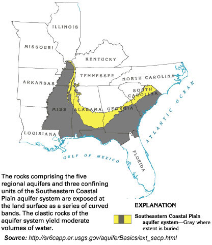
The Southeastern Coastal Plain aquifer system consists of four regional aquifers that are composed predominately of clastic rocks ranging in age from Cretaceous to late Tertiary. The
southern and southeastern limits of the aquifer system extend past
the coastline in most places. That is, the rocks that comprise some
of the water-yielding units of the aquifer system are permeable
enough to maintain their character as aquifers for some distance
offshore. However, the aquifers contain saltwater with dissolved-solids
concentrations of 10,000 milligrams per liter or more near the coast
in most areas. The northern limit of the aquifer system is its contact
with crystalline rocks or consolidated sedimentary rocks of Paleozoic
age at the Fall Line, which marks the updip extent of Coastal Plain
sediments. Rocks of the Southeastern Coastal Plain aquifer system were deposited in fluvial, deltaic and shallow-marine environments during a series of transgressions and regressions of the sea. Coarser grained, fluvial to deltaic sediments are located primarily near the updip extent of the aquifer system and consist primarily of coarse sand and gravel that form productive aquifers. Most of the aquifers in the system, however, consist chiefly of fine to coarse sand. Confining units within the system are mostly silt and clay, except for a thick sequence of chalk in Alabama and Mississippi. All these fine-grained materials form effective confining units that retard the vertical movement of ground water, especially where they are thick. The proportion of clay in the aquifer system generally increases in the direction of the coastline; thus, even though the system thickens in this direction, its overall transmissivity is much less toward the coastline. The interbedding of coarse- and fine-grained sediments is complex because of fluctuating sea level and resulting changes in energy conditions and in depositional environments. Rock types and textures may change greatly within short vertical or horizontal distances. |
 |
|